 Drone Buddy
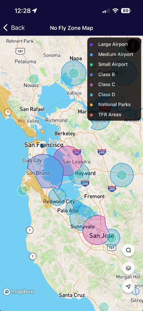
The map answers a simple question before you take off: what restricted airspace is near this pin? It is a planning overlay, not a clearance, not LAANC, and not a substitute for faa.gov/uas or a B4UFLY app when you need authorization.
Want a walkthrough of each layer? Read understanding the no-fly zone map.
Latest update — September 2026
We stopped treating every U.S. towered airport as a round “no-fly” disc. Controlled airspace has a published outline. Class B is a wedding cake: a surface core, then outer rings that often start thousands of feet up. A 400 ft drone can sometimes fly under those shelves. Painting the whole cake as red was the old bug.
- FAA Class B / C / D surface polygons from the NASR 28-day cycle dated 3 September 2026. We keep only airspace that starts at the surface (
LOWER_CODE = SFC). 724 polygons: 40 Class B, 122 Class C, 562 Class D. - Airport points still come from OurAirports, with closed/abandoned names filtered on rebuild. Heliport circles stay off by default so a city is not a yellow blanket.
- TFRs and UAS restrictions still load live when you open the map.
How we draw each layer
| Layer | Source | Shape | How we use it |
|---|---|---|---|
| Class B, C, D (U.S.) | FAA NASR Class Airspace shapefiles | Real polygons | Surface only. Outer Class B/C shelves that start at 2,000–4,000 ft MSL are omitted so flyable air stays unpainted. |
| Airports (worldwide) | OurAirports | Point + optional safety radius | Large, medium, and small aerodromes. Heliports hidden by default. Circles are a caution radius, not the legal FRZ. |
| National parks | NPS / Natural England / Parks Canada open GIS | Park polygons | U.S., U.K., and Canada park boundaries as published by those agencies. |
| TFRs / UAS restrictions | FAA UAS data, cached live | Polygons | Fetched when you open the map. Tap a red area for the FAA notice when a URL is attached. |
Data sources
Full weather, Kp, and copyright notes live on the Data Sources page.
What this map is not
- Not a LAANC USS. We do not issue FAA authorization. For that, use an FAA-listed B4UFLY / LAANC app.
- Not a DJI geofence. DJI can still refuse takeoff even when this overlay looks open, and the reverse is also true.
- Not a permit for a park, city, or private field. Takeoff and landing are local rules.
No-fly overlays are a reference. Airspace, TFRs, and park rules change. Always confirm official sources before flight. Drone Buddy is not affiliated with the FAA.